CCTV News:According to the website of the Central Meteorological Observatory, due to the combined influence of cold air and David, most of the East China Sea, Taiwan Province Strait, east of Taiwan Province, bashi channel, most of the South China Sea, Beibu Gulf, Zhejiang coast, Fujian coast, eastern and southern coast of Hainan Island will have 7 ~ 8 winds, and some areas of Hainan Island have small to moderate rain and local heavy rain (25 ~ 40 mm); From the night of the 4th to the morning of the 7th, the atmospheric diffusion conditions in the central and southern parts of North China and the central and western parts of Huanghuai deteriorated, with mild to moderate haze and severe haze locally.
1. Some areas such as Jilin, Liaoning and Huanghuai in North China have cooled down.
Yesterday, there was no precipitation in most parts of the country, moderate rain occurred in some parts of western Yunnan, and heavy rain fell locally. At 5 o’clock today, compared with 5 o’clock yesterday, the temperature dropped by 6 ~ 8℃ in eastern Jilin, eastern Liaoning, eastern and southern North China, and eastern Huanghuai, and the local temperature dropped by 10 ~ 12℃.
Second, the key weather forecast
1. There is strong stormy weather in the South China Sea.
This year’s No.23 typhoon "Davy" was strengthened into a strong typhoon last night. Its center was located in the southwest of the South China Sea about 70 kilometers northeast of Nha Trang City, Qinghe Province, Vietnam at 5 o’clock on the morning of the 4th, which was 12.7 degrees north latitude and 109.7 degrees east longitude. The maximum wind force near the center was 14, and the lowest pressure in the center was 965 hectopascals. It is estimated that "Davy" will continue to move westward at a speed of about 25 kilometers per hour, and will soon land along the coast of southern Vietnam, and its intensity will weaken rapidly after landing. Affected by cold air and Davy, there will be 7-8 winds in most parts of the East China Sea, Taiwan Province Strait, the east of Taiwan Province, bashi channel, most parts of the South China Sea, Beibu Gulf, Zhejiang coast, Fujian coast, and the eastern and southern coasts of Hainan Island. Among them, there are 9 winds in the Taiwan Province Strait, 9-10 winds in the southwestern part of the South China Sea, and 11-13 winds in the nearby waters where Davy Center passes. Some parts of Hainan Island have moderate to moderate rain and local heavy rain (25 ~ 40mm). In addition, there will be heavy rain in the western part of the South China Sea, and there will be heavy rain (100 ~ 150 mm) in some sea areas. The Central Meteorological Observatory continued to issue a blue typhoon warning at 06: 00 on the 4th (see Figure 1).
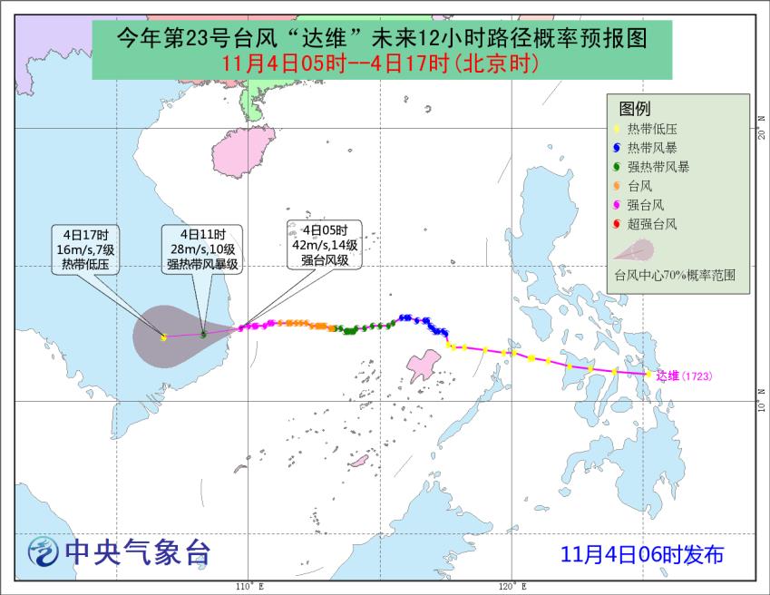
Fig. 1 The path probability forecast chart of the 23rd typhoon "Davy" in the next 12 hours this year.
There was haze in Beijing-Tianjin-Hebei and surrounding areas from the night of 2. 4th.
From the night of the 4 th to the morning of the 7 th, the atmospheric diffusion conditions in the central and southern parts of North China and the central and western parts of Huanghuai deteriorated, with mild to moderate haze and severe haze in the local area; There is fog in some areas from night to morning; On the morning of the 7th, due to the influence of cold air, the haze weather in the above areas gradually weakened or dissipated from north to south.
On March 5th, cold air affected the northern region from west to east.
From May 5th to 7th, a cold air will affect the northern region from west to east in Xinjiang, and the temperature in most of the above areas will drop by 4 ~ 6℃, and the temperature in southeastern Inner Mongolia, southern Northeast China and parts of northern North China will drop by 8 ~ 10℃.
Third, the future specific forecast
From 08: 00 on the 4 th to 08: 00 on the 5 th, there were small to moderate rains (snow) or sleet in parts of northern Xinjiang and other places. Among them, there were moderate to heavy snow in Altay, Xinjiang and high-altitude areas along Tianshan Mountain, and local snowstorms; Some areas in the western Sichuan Basin, Hainan Island, Taiwan Province and other places have moderate to moderate rain and local heavy rain (Figure 2).

Figure 2 National Precipitation Forecast Chart (08: 00 on November 4-08: 00 on November 5)
From 08: 00 on the 5 th to 08: 00 on the 6 th, there were small to medium snow or sleet in high-altitude areas in northern Xinjiang and southeastern Tibet; There are small to moderate rains or showers in western Sichuan Basin, southeastern Yunnan, Hainan Island and Taiwan Province. There are 4 ~ 6 winds in most parts of Inner Mongolia, Northeast China and Shandong Peninsula (see Figure 3).

Figure 3 National Precipitation Forecast Chart (08: 00 on November 5-08: 00 on November 6)
From 08: 00 on the 6 th to 08: 00 on the 7 th, there were small to medium snow or sleet in the western mountainous areas of northern Xinjiang, eastern Inner Mongolia, southern Heilongjiang and northwestern Jilin. Among them, the western mountainous areas of northern Xinjiang had heavy snow; There are small to moderate rains in the central part of Northeast China, western Sichuan Basin, coastal areas of Zhejiang and Fujian, southern and western South China, southern Yunnan, southern Guizhou, Hainan Island, Taiwan Province and other places. Among them, there are heavy rains in parts of Hainan Island and Taiwan Province, and heavy rains (100 ~ 110 mm) in the southeast of Hainan Island. There are 4 ~ 6 winds in most parts of Inner Mongolia, northern North China, southern Northeast China, Hexi Corridor and Shandong Peninsula (see Figure 4).

Figure 4 National Precipitation Forecast Chart (08: 00 on November 6-08: 00 on November 7)
Fourth, the impact and concern
1. Rain, snow and windy weather in northern Xinjiang;
2. The wind and rain impact of Typhoon David on the South China Sea and Hainan Island;
3. Gale weather and its influence in the East China Sea and Taiwan Province Strait;
On April 4-6, the haze weather process in central and southern North China.