CCTV News:According to the website of the Central Meteorological Observatory, due to the influence of strong cold air, it is estimated that from 08: 00 on January 22 to 08: 00 on January 25, the temperature in most parts of central and eastern China will drop by 6 ~ 10℃, and the temperature in northern North China, eastern Northeast China and eastern Jiangnan will drop by 12~14℃, exceeding 18℃ in some places. There are 4 ~ 6 winds and 7 ~ 8 gusts in these areas, western Gansu and western Inner Mongolia. In the next two days, there will be small to medium snow or sleet in northern Xinjiang, southern Gansu, central and eastern Inner Mongolia, northern and eastern North China, eastern Huanghuai, eastern and southern Northeast China, and there will be small to moderate rain in eastern Southwest China, Jianghuai, Jianghan, Jiangnan and South China from 22nd to 23rd.
There is strong wind and cooling weather in the central and eastern regions.
Influenced by strong cold air, it is estimated that the temperature will drop by 6 ~ 10℃ in most parts of central and eastern China from 08: 00 on January 22 to 08: 00 on January 25, while it will drop by 12~14℃ in northern North China, eastern Northeast China and eastern Jiangnan, with local winds exceeding 18℃. There are 4 ~ 6 winds and gusts of 7 ~ 8 in these areas, and some areas in western Gansu, western Inner Mongolia and Ningxia. There are 6 ~ 8 winds and 9~10 gusts in most offshore areas of China. The lowest temperature in the process appears on the morning of 24th to 25th, and the lowest temperature line of 0℃ will be located in the east of Yunnan, south of Guizhou and north of South China.
Among them, from 08: 00 on January 22 to 08: 00 on January 24, the temperature in parts of northern Xinjiang, eastern northwest, south-central northeast, North China, Huanghuai, Jianghuai, northern and southwestern Jiangnan and central South China will drop by 6 ~ 8℃ successively, and the temperature in parts of central and southeastern Inner Mongolia, eastern Jilin, Liaoning and north-central Shanxi will reach 10 ~ 14℃, accompanied by 4℃ in these parts. There are 6 ~ 8 winds and 9~10 gusts in the northern and eastern seas. The Central Meteorological Observatory continued to issue a cold wave blue warning at 06: 00 on January 22.
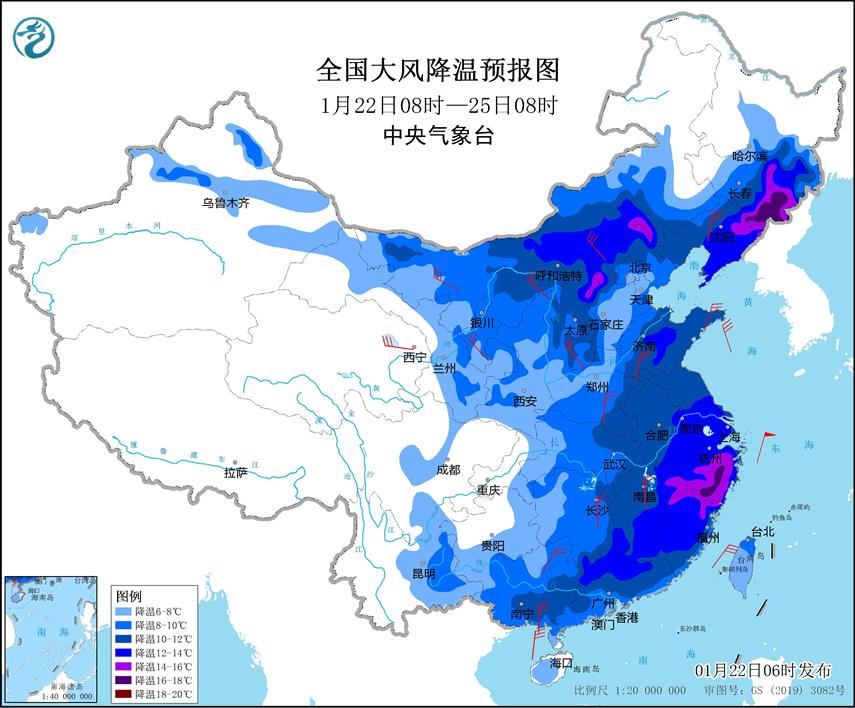
National gale cooling forecast chart (08: 00 on January 22-08: 00 on January 25)

National Minimum Temperature Forecast Chart (08: 00 January 22-08: 00 January 25)

National gale cooling forecast chart (08: 00 January 22-08: 00 January 24)
There is little to medium snow in the northeast of northern North China.
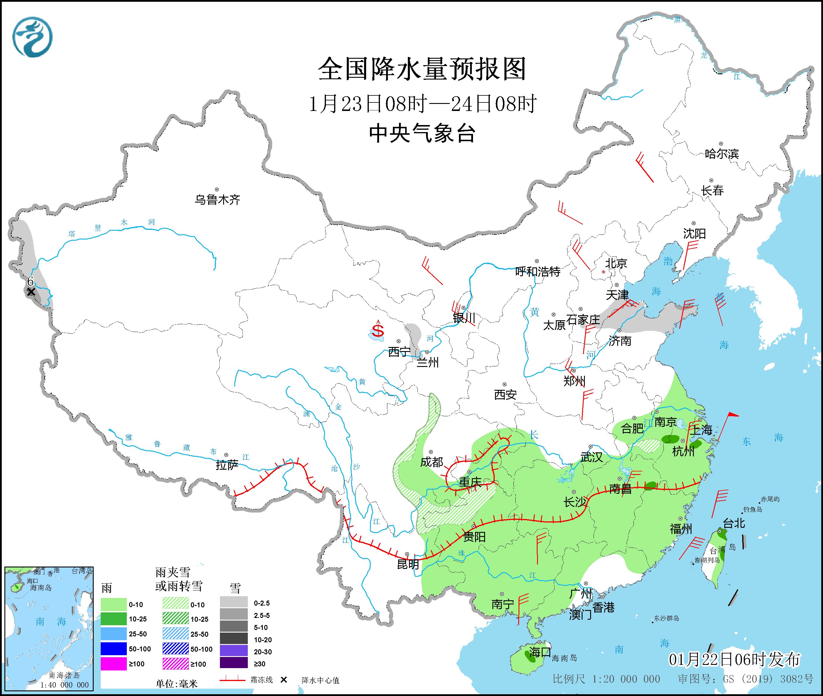
In the next two days, there will be small to medium snow or sleet in northern Xinjiang, southern Gansu, central and eastern Inner Mongolia, northern and eastern North China, eastern Huanghuai and eastern and southern Northeast China. In addition, from 22nd to 23rd, there were small to moderate rains in the eastern part of southwest China, Jianghuai, Jianghan, Jiangnan and South China.
In addition, since the 24th, there has been continuous snowfall in western Tibet, with heavy snowstorms on the line from Pulan to Nyalam.
Specific forecast for the next three days
From 08: 00 on January 22 to 08: 00 on January 23, there were small to medium snow or sleet in parts of north-central North China, south-central Northeast China, western and southern Gansu. There is light rain in parts of eastern and southern Jianghuai, southern Jianghan, eastern Southwest, south of the Yangtze River and most parts of southern China. There are 4 ~ 6 winds in parts of central and western Inner Mongolia, Liaodong Peninsula, Hexi in Gansu, Shandong Peninsula and northern Zhejiang. There are 6-8 grades and 9-10 grades of north-northeast winds in Bohai Sea and Bohai Strait.

National Precipitation Forecast Chart (08: 00 January 22-08: 00 January 23)
From 08: 00 on January 23 to 08: 00 on January 24, there were small to medium snow or sleet in parts of western mountainous areas of southern Xinjiang, southeastern Hebei, northern Shandong and northern Guizhou, and there was heavy snow (5 ~ 6 mm) in the local area. There are light rains and moderate rains in parts of the central and eastern Jianghuai, Jiangnan, the eastern part of Southwest China, and most of South China. There are 4 ~ 6 winds in parts of the south of Northeast China, North China, Huanghuai, northern Jiangnan, northern South China and southern coastal areas. The Bohai Sea, the Bohai Strait, most of the Yellow Sea, most of the East China Sea, the Taiwan Province Strait, the east of Taiwan Province, the northern part of the South China Sea and the Beibu Gulf will have northerly winds of 6-8 grades and gusts of 9-10 grades, among which the winds in parts of the Taiwan Province Strait and the east of Taiwan Province can reach 9 grades and gusts of 10-11 grades.
National Precipitation Forecast Chart (08: 00 January 23-08: 00 January 24)
From 08: 00 on January 24 to 08: 00 on January 25, there were small to medium snows in parts of mountainous areas in northern and western Xinjiang, western and southern Tibet, and heavy snowstorms (10 ~ 19 mm) in parts of western Tibet. There are light rains or showers in parts of the eastern part of Southwest China, southern Yunnan, Hainan Island and Taiwan Province Island. There are 4 ~ 6 winds in parts of north-central North China, Shandong Peninsula, Liaodong Peninsula, eastern and southern Jiangnan, and southern coastal areas of South China. The Bohai Sea, the Bohai Strait, most of the Yellow Sea, most of the East China Sea, the Taiwan Province Strait, the east of Taiwan Province, the northern part of the South China Sea and the Beibu Gulf will have northerly winds of 6-8 grades and gusts of 9-10 grades, among which the winds in parts of the Taiwan Province Strait and the east of Taiwan Province can reach 9 grades and gusts of 10-11 grades.

National Precipitation Forecast Chart (08: 00 January 24-08: 00 January 25)