Just now, "Du Surui" landed on the coast of Jinjiang.
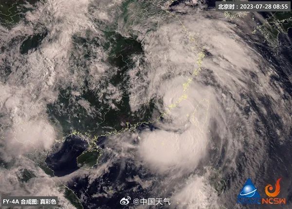
At around 9: 55 today (July 28th), the No.5 typhoon "Du Surui" landed on the coast of Jinjiang, Fujian Province with violent storms, becoming the strongest typhoon landing in China this year, and the second strongest typhoon landing in Fujian since the complete observation record, tied with No.15 typhoon in 1980. "Du Surui" will continue northward after landing, and its residual circulation will even affect North China, Northeast China and other places. There will be heavy rains in more than 10 provinces, and even heavy rains in Zhejiang, Fujian and other places. It is necessary to be alert to destructive storms.
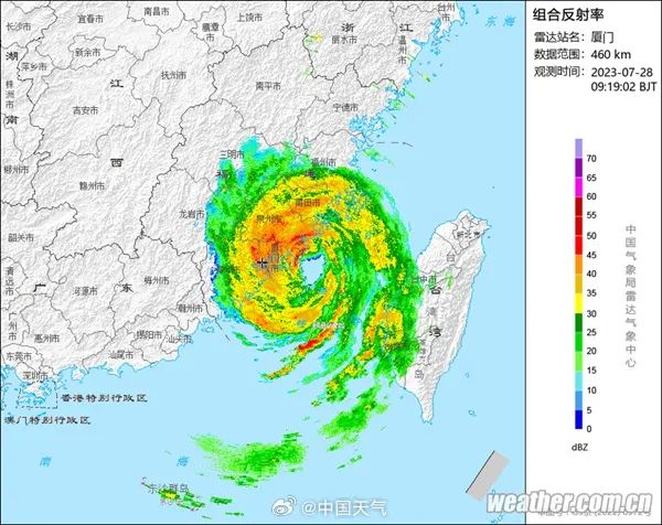
According to the monitoring of the Central Meteorological Observatory, the center of the No.5 typhoon "Du Surui" this year landed in the coastal area of Jinjiang, Fujian around 9: 55 today. At the time of landing, the maximum wind force near the center was 50 meters per second, the intensity was strong typhoon, and the lowest pressure in the center was 945 hectopascals.
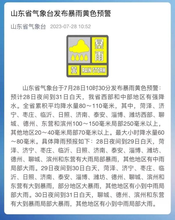
Shandong Meteorological Observatory in
At 10: 30 on July 28,
Release the No.5 typhoon "Du Surui" forecast.
And yellow rainstorm warning
↓↓↓
It is estimated that "Du Surui" will move to the north-west direction at a speed of 25 kilometers per hour, and its intensity will weaken rapidly. On the 29th, it will weaken into a tropical depression (magnitude 6-7), and on the 30th, it will continue northward through the western part of our province.
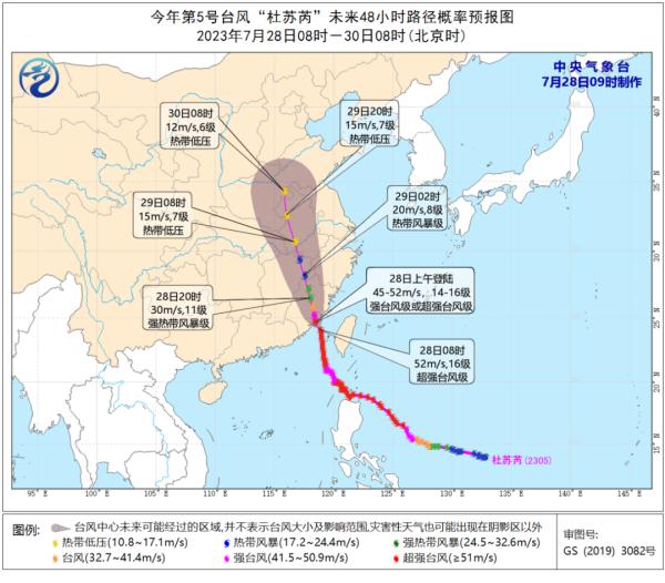
△ Forecast chart of the moving path of Typhoon Du Surui No.5..
The influence of "Du Surui" on our province is mainly rainfall. It is estimated that there will be heavy precipitation in the western and central areas of our province from the night of the 28th to the day of the 31st. The cumulative average precipitation in the whole province is 80 ~ 110mm, of which Heze, Jining, Zaozhuang, Linyi, Rizhao, Jinan, Taian, Zibo, Weifang West, Liaocheng, Dezhou, Dongying and Binzhou are 100 ~ 150mm, and the others are 20 ~ 40mm, and the others are over 70mm. The maximum hourly precipitation is 60 ~ 80mm. At the same time, the wind gradually increases from south to north, with 7 gusts in the southeast wind, the central Yellow Sea and Bohai Sea, and 8 gusts in the Bohai Strait, the northern Yellow Sea and inland areas.
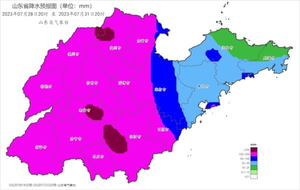
△ Precipitation forecast chart from 20: 00 on July 28th to 20: 00 on July 31st, 2023 (unit: mm).
Shandong province flood prevention and drought relief headquarters office
Issue notice requirements,
Fully estimate this typhoon
The most serious impact that may be caused,
Compaction, compaction, flood control and typhoon prevention responsibilities,
Do enough to do all kinds of defensive measures.
Do a good job in monitoring, forecasting and early warning According to reports, the impact of "Du Surui" on our province is mainly rainfall, which will mainly start from July 29. It is necessary to pay close attention to the trend of Typhoon Du Surui and the rain, water and flood conditions, timely organize the departments of natural resources, housing construction, water conservancy, agriculture and rural areas, emergency and meteorology to jointly discuss and judge, and make rolling forecasts. According to the results of the consultations, timely issue early warnings and start responses, focus on monitoring and early warning of local heavy rainfall, mountain torrents, landslides and mudslides, ensure that monitoring and early warning are in place, and effectively enhance the initiative and foresight of work. We should make full use of radio, television, SMS, Internet and other channels to widely release early warning information to remind the public to take scientific precautions and effectively avoid disasters and risks. It is necessary to strictly implement the emergency "response" mechanism, so as to realize the first-time "response", the first-time response and the first-time disposal of flood control responsible persons at all levels.
Continue to carry out hidden dangers investigation. It is necessary to continuously carry out dragnet investigations on important areas and key parts of flood control and typhoon prevention, such as projects under construction, small reservoirs, ponds, small and medium-sized rivers, hidden points of geological disasters, urban waterlogging-prone points, industrial and mining enterprises, tailings ponds, tourist attractions, etc., and promptly rectify hidden dangers when found, and resolutely and completely eliminate potential risks. We should pay close attention to the dredging of rivers, drainage pipe networks, culverts, rain outlets and drainage pumping stations in urban areas, comprehensively investigate high-altitude structures such as billboards and glass curtain walls, and lodging objects such as tower cranes, fences and street trees, and properly strengthen or dismantle them to ensure the safe operation of the city.
Scientifically dispatch water conservancy projects. At present, the storage capacity of large and medium-sized reservoirs in the province is on the high side, so it is necessary to do a good job in the operation and management of water conservancy projects based on the most unfavorable situation of resisting strong typhoons and heavy rains. It is necessary to analyze the rain-receiving capacity in combination with the meteorological forecast, pre-discharge the reservoir in advance, and keep sufficient flood control capacity. It is necessary to scientifically dispatch flood control projects, co-ordinate the upstream and downstream, the left and right banks, the main tributaries, open the floodgates and dams in advance, scientifically dispatch flood interception, peak shifting and flood detention, and maximize the flood control and disaster reduction benefits of water conservancy projects. It is necessary to strengthen the inspection and protection of water conservancy projects, especially for small reservoirs, ponds and dangerous sections, and assign special personnel to patrol and watch for 24 hours. Once dangerous situations are found, it is necessary to quickly organize emergency protection, eliminate dangerous situations in time, and ensure project safety and personnel safety.
Strengthen the focus on key parts. It is necessary to do a good job in the work of ships returning to Hong Kong to take shelter from the wind, offshore operators and offshore fishing rafts and aquaculture personnel going ashore to avoid risks, and strengthen the supervision of ships returning to Hong Kong, "three noes" ships and inter-provincial sheltered fishing boats, so as not to miss a boat or leave a person. It is necessary to keep a close eye on key parts such as subways, underground shopping malls, culverts, tunnels, sunken overpasses, shanty towns, and low-lying and waterlogged areas in cities, equip them with mobile drainage equipment, implement information monitoring means, and implement emergency evacuation, traffic control and evacuation measures one by one to fully ensure the safe operation of cities. It is necessary to pay close attention to the work of safety in production during the typhoon, guide the flood control work of key parts such as chemical parks, industrial and mining enterprises, high-temperature molten metal, projects under construction, and important infrastructure such as electric power, transportation, communication and municipal administration, and resolutely avoid production safety accidents. It is necessary to focus on personnel transfer to avoid risks, keep a close eye on key areas such as flash flood disaster-prone areas, hidden dangers of geological disasters, dangerous sections, overhead warehouses, tailings ponds, tourist attractions, etc., scientifically judge floods and dangers, and resolutely and decisively transfer people in dangerous areas, so as to prevent casualties caused by inadequate and incomplete transfer.
Make solid preparations for emergencies. It is necessary to strictly implement the 24-hour duty and leadership shift system, strictly observe the duty discipline, fully grasp the rain, water, work conditions, dangers and disasters in a timely manner, effectively improve the timeliness and accuracy of information submission, and resolutely put an end to late reporting, concealment and omission. Rescue forces at all levels should be ready for emergency rescue in advance to ensure that in case of danger and disaster, they can deal with it at the first time.
Pay attention to Qingdao together
Weather conditions in the next few days
↓↓↓
Qingdao Meteorological Observatory released at 6: 00 on July 28th:
[Qingdao City] During the day, it turned cloudy and cloudy with showers or thunderstorms. When the southeast wind turned from 3 to 4 to 4 to 5, the gust was 7 to 9. At night, there was moderate rain and partial heavy rain accompanied by lightning. When the southeast wind was 4 to 5, the gust was 7 to 9. Today, the highest temperature was 29 C, the lowest temperature was 26 C, and the relative humidity was 80%-100%.
Day to night on July 29th: It is cloudy with light rain to moderate rain accompanied by lightning, and the gusts are 7-9 and 27-29℃ when the southeast wind is 4-5 thunderstorm.
Day to night on July 30: There are showers or thunderstorms in the shade. When the southeast wind turns from 4 to 5 to 5 to 6, the gust is 9, 26 to 29℃.
[Forecast areas] Today, from day to night, it turns cloudy with moderate rain and local heavy rain accompanied by lightning, southeast wind, gusts of 7-9 when there is a 5-6 thunderstorm at sea, and gusts of 7-9 when the inland 3-4 turns to 4-5 thunderstorm.
Day to night on July 29th: It is cloudy with light rain to moderate rain accompanied by lightning, and the southeast wind is 4-5, and the gust is 7-9 during the thunderstorm.
Day to night on July 30: There are showers or thunderstorms in the shade, and there is heavy rain in some parts of the western region. When the southeast wind turns from 4 to 5 to 5 to 6 thunderstorms, the gust is 9.
Comprehensive self-observation news client, Volkswagen Daily, Central Meteorological Observatory, @ Shandong Weather, @ Qingdao Meteorology, etc.
]