Chen Chao, correspondent of Science and Technology Daily in Japan
Not long ago, Japan launched the fourth Quasi-Zenith System (QZSS) "Pathfinder" 4 satellite that can be used for satellite navigation and positioning, and its announced centimeter-level positioning accuracy has attracted widespread attention. Regarding the latest progress of Quasi-Zenith satellites, a reporter from Science and Technology Daily interviewed satellite positioning expert Liu Zhixing, a visiting professor at York University in Canada.
Three characteristics of quasi-zenith system
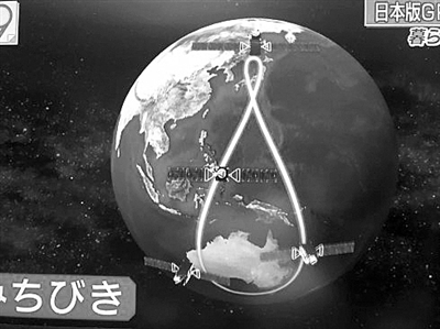
Liu Zhixing first introduced that the quasi-zenith system has three satellites in tilt-synchronous orbit working over Japan, rotating alternately for 8 hours, so as to ensure that a satellite with a higher elevation angle is on duty in Japan’s "zenith" at any time, which makes it possible for this satellite, which will not be blocked, to "supplement" GPS’s positioning ability in harsh environments in urban centers and valleys. The successful launch of the No. 4 satellite will, together with the three satellites launched before, form a regional satellite navigation and positioning assistance enhancement system that can cover Japan and the surrounding area. Now Quasi-zenith is in the practice run stage. It will officially provide services to Japan and surrounding areas in 2018, and increase to seven satellites in 2023. It is possible to expand into a regional navigation system that does not rely on GPS and operates independently.
Secondly, the positioning accuracy is enhanced. Quasi-Zenith satellites provide two GPS enhancement signals: L1S and L1Sb (starting to provide SBAS satellite-based enhancement services in 2020) can provide sub-meter-level positioning accuracy enhancement services, enabling users in Japan to improve their positioning accuracy from 10 meters when relying only on GPS to about 1 meter; the other is centimeter-level enhancement signal L6, including L6D and L6E, which can perform precise single-point positioning.
Finally, the quasi-zenith system can also provide warning services, including disaster warnings such as earthquakes and tsunamis; when GPS satellites are abnormal, users can also be notified in time to avoid wrong positioning.
Positioning accuracy up to 6 cm
According to Japanese media reports, the positioning accuracy of the quasi-zenith system can reach 6 cm after the deployment of the first phase, including three tilt-synchronous orbit satellites and one geosynchronous orbit satellite. What technology is used to achieve this order of magnitude difference?
Liu Zhixing explained that the centimeter-level positioning accuracy that the quasi-zenith satellite navigation system can achieve is achieved by the enhancement of GPS by the L6 signal. The precision single-point positioning provided by it is a key technology for achieving global precision real-time dynamic positioning and navigation. It is also a cutting-edge research direction in global navigation satellite system (GNSS) positioning, but it is not unique to Japan. In application, the L6 signal is not compatible with GPS signals, and special receivers and antennas are required for reception. It can be used in high-precision measurement, high-precision construction of construction machinery, and IT precision agriculture. Due to the large size of the antenna and receiver, it cannot be compared with mobile end points such as mobile phones. At this stage, it can only be used for measuring instruments and vehicles.
Quasi-Zenith Technical Advantages and Controversies
By 2023, when the number of Quasi-Zenith satellites reaches 7, it will have the ability to work independently from the GPS system and become Japan’s regional satellite navigation system. This process provides an in-orbit platform for testing and demonstration, which will greatly promote Japan’s independent research and development capabilities in the field of satellite navigation. However, in terms of applications, some media have pointed out that because Quasi-Zenith is a regional system, it cannot be popularized and may fall into a vicious circle of evolution alone.
Liu Zhixing said that the quasi-zenith system is not globally oriented, and only receivers that can be used in and around Japan cannot guarantee the market scale. Although the field of autonomous driving is one of the application hotspots of high-precision positioning, due to the positioning time and the delay of satellite channel transmission, it can only be used as an auxiliary of other sensors at this stage, and the Japanese business community has not responded very enthusiastically. However, looking to the future, in the fourth stage of autonomous driving, that is, the driving stage dominated by artificial intelligence, the absolute position of centimeter-level accuracy is very necessary. Assuming that the mass production price of L6 corresponding to high-precision chips can reach less than 1,000 yen by then, which is better than the relative positioning sensors such as cameras and LIDAR that are currently relied on for autonomous driving, then the quasi-zenith system may have some competitiveness.
Beidou is a complete global satellite navigation system
Liu Zhixing concluded by saying that China’s Beidou satellite navigation system is starting global construction, and the construction of the enhancement system is also underway. In terms of space-based enhancement, recently, at the fourth meeting of the ICAO Navigation System Expert Group, the Beidou Satellite-based Augmentation System (BDSBAS) was officially awarded the SBAS system supplier ID and system time ID. BDSBAS became the sixth satellite-based augmentation satellite navigation system in the world, providing sub-meter-level services for aviation applications. In addition, Hezhong Sytron has been developing the centimeter-level Beidou satellite-based augmentation system since 2013. We can collectively expect "Chinese precision".
(Science and Technology Daily, Tokyo, November 9)